
Published 7 September 2026 · Updated 30 September 2026 · By Jatin Dua, Broker of Record, RE/MAX Quantum Realty
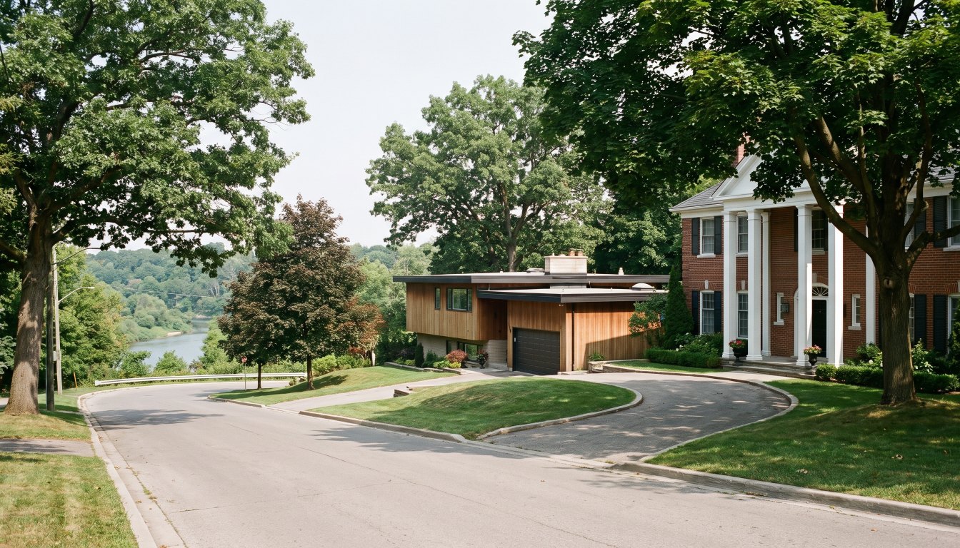
Humber Valley Village runs from Dundas Street south to Eglinton Avenue north, Islington Avenue west to the Humber River east. The land was laid out in farm lots by 1805 but stayed undeveloped for over a century. Robert Home Smith built his own estate, Edenbridge, here around 1900, then developed the area through Humber Valley Surveys from the mid-1930s — continuing after his death in 1935 — into the 1960s.
That long build-out is why the architecture is so varied: Georgian, Colonial, Tudor, English Cottage, Cape Cod, ranch, split-level and modernist, often side by side. The eastern edge runs to the Humber River with extensive parkland along the west bank, which brings ravine and conservation authority rules into play for riverside lots.
A century of waiting, then thirty years of building
The land was laid out in farm lots by 1805 and then sat largely undeveloped for more than a hundred years. Robert Home Smith — the same developer behind The Kingsway and Baby Point — built his own estate here, Edenbridge, around 1900. Development through Humber Valley Surveys began in the mid-1930s, continued after his death in 1935, and ran into the 1960s.
Why the mixed architecture is a feature
Georgian, Colonial, Tudor, English Cottage, Cape Cod, ranch, split-level and modernist houses all appear here, frequently on the same street. That is not inconsistency — it is the record of a build-out that crossed the Depression, the Second World War and the postwar boom.
Commercially it matters in a specific way: comparables are harder. Two houses of the same size on the same street can be thirty years apart in construction, with completely different structures, ceiling heights and systems. Pricing here leans more heavily on land value and replacement cost than in a neighbourhood built out in a single decade.
The river edge
The eastern boundary is the Humber River, with extensive parkland along the west bank. For properties near it, two regimes can apply:
- Municipal Code Chapter 658. Inside a mapped ravine protected area, a permit is required to injure, destroy or remove a tree, place or dump fill, or alter the grade of land. Fines run $500 to $100,000 per tree.
- TRCA, O. Reg. 41/24. Where the property is in a regulated area, TRCA clearance is required before the City will issue a building permit.
And everywhere in the neighbourhood, Chapter 813 requires a permit for any privately owned tree 30 centimetres or more in trunk diameter.
Where it sits in the west-end market
The west end of Toronto as a whole recorded 31 sales above $3 million between January and April 2026 — roughly comparable to York Region at 35 and ahead of Peel Region at 24. Humber Valley Village is one of the enclaves that produces that figure, alongside Kingsway South at 9, Baby Point and the Old Mill area.
What to check
- Construction era of the specific house, because it varies enormously here and drives everything about condition and systems.
- The survey, and table land versus slope on river-facing lots.
- Ravine and TRCA mapping, separately, for the address.
- A tree count of anything 30 centimetres or more.
- Permit history for past additions — three decades of build-out plus sixty years of alterations means most houses have been changed.
- Drainage, particularly on sloped lots toward the river.
The practical takeaway
Humber Valley Village is a Home Smith neighbourhood without a heritage district, which means more freedom and less guarantee than Baby Point next door. Judge each property on its own construction era and its own lot, and treat the river edge as a regulated zone rather than simply a nice view.
Frequently asked questions
What are the boundaries of Humber Valley Village?
Dundas Street to the south, Islington Avenue to the west, Eglinton Avenue to the north and the Humber River to the east.
Who developed it?
Robert Home Smith, through Humber Valley Surveys. He built his own estate, Edenbridge, in the area around 1900. Construction ran from the mid-1930s, continued after his death in 1935, and extended into the 1960s.
Why is the architecture so mixed?
Because the build-out spanned roughly three decades across the Depression, the war and the postwar boom. Georgian, Colonial, Tudor, English Cottage, Cape Cod, ranch, split-level and modernist houses all appear, reflecting when each lot was built on rather than any inconsistency of planning.
What do riverside lots involve?
Properties toward the Humber River can fall within mapped ravine protected areas under Municipal Code Chapter 658 and within TRCA regulated areas under O. Reg. 41/24. In a protected area a permit is required to injure, destroy or remove a tree, place or dump fill, or alter grade; where TRCA applies, clearance is needed before a building permit issues.
Which schools serve the area?
Humber Valley Village Junior Middle School, which opened in 1951, is the TDSB school in the neighbourhood. Private options in the wider area include Kingsway College School, Kingsley Primary School and Leonardo da Vinci Academy. Confirm catchments with the school board.
How does it compare with The Kingsway?
Both were Home Smith developments and both sit on the Humber, but The Kingsway was built out mainly in the 1920s under design approval, giving a more consistent Arts and Crafts streetscape, while Humber Valley Village spans the 1930s to the 1960s and is architecturally varied. Kingsway South recorded 9 sales above $3 million between January and April 2026, within a west-end total of 31.
Thinking about buying or selling at the top end?
Send me the address, or the shortlist you are considering. I will tell you what the property is actually worth today, what the land is worth without the house, what the transfer tax and carrying costs will be, and whether the deal makes sense. Confidential, always.
[email protected] · 833-330-1925 · Book a free consultation
Confidential. Read personally and answered within 24 hours. I never share, sell or distribute your information.
Related reading
- The Kingsway: how one developer’s rules still set prices
- Baby Point: a heritage district on top of a 17th-century village
- Buying a ravine lot in Toronto: what the bylaw does to your plans
- West Toronto vs North Toronto luxury: two different kinds of money
Sources
Everything above that is a rule, a rate or a published number comes from these. Verify anything that matters to your own deal.
- City of Toronto — Municipal Code Chapter 658, Ravine and Natural Feature Protection
- Toronto and Region Conservation Authority — Replacing an existing home
- RE/MAX Canada — 2026 Spotlight on Luxury Real Estate, Greater Toronto
About the author — Jatin Dua, Broker of Record
I’m the Broker of Record at RE/MAX Quantum Realty, 799 The Queensway in Etobicoke, and I work with buyers, sellers and investors across Toronto and the west GTA. A large part of my work sits in the upper end of the market, where the comparables are thin, the rules are heavier and the cost of a wrong number is measured in hundreds of thousands of dollars.
The free estimators on this site are mine. I built them because the first question every owner asks is “what is it worth?” and the honest answer starts with a number you can check yourself. [email protected] or 833-330-1925.