

Published 26 September 2026 · By Jatin Dua, Broker of Record, RE/MAX Quantum Realty
Niagara-on-the-Lake’s Old Town sits where the Niagara River meets Lake Ontario, and its waterfront comes in three forms: the river edge, largely Niagara Parks Commission and federal land along the Parkway; the Old Town lakefront around Queen’s Royal Park and Ryerson Park; and the rural lakeshore running west toward Four Mile Point, where local reporting documents erosion of roughly 1.1 metres a year and about 90 metres of shoreline lost since 1950 at Niagara Shores Park, and where Parks Canada has spent $10.4 million on breakwalls to save Fort Mississauga. Old Town has been a heritage conservation district since 1986 and Council adopted an expanded Old Town district plan by By-law 2026-015 on 24 March 2026. Short-term rentals are licensed under By-law 2025-032 in five classes at $800 new and $600 renewal. There is no GO train. TRREB’s April to June 2026 report put the Town community’s average at $1,343,314 and the Lakeshore community’s at $1,574,750 on four sales.
Three waterfronts in one town
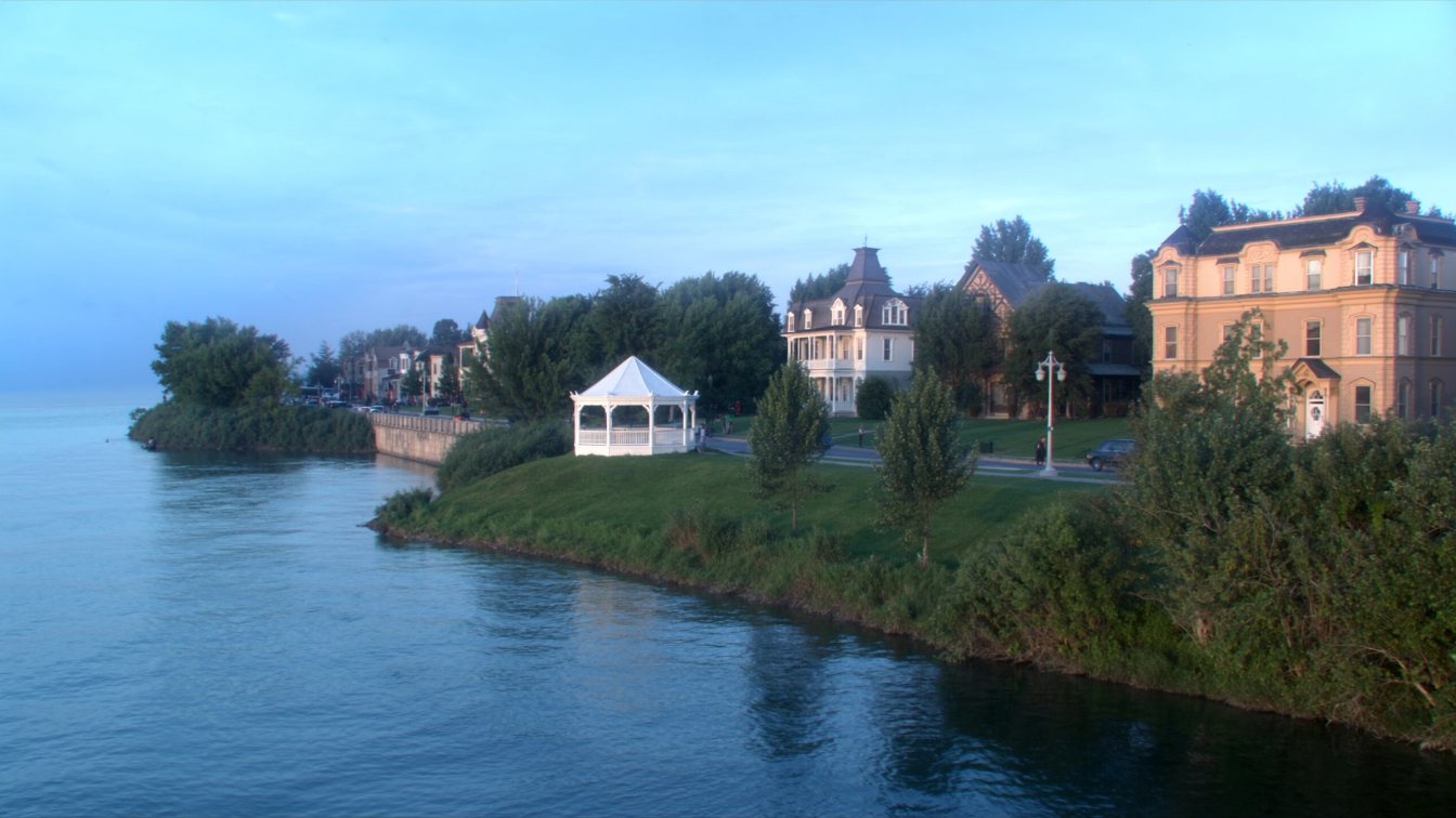
Niagara-on-the-Lake’s Old Town occupies the point where the Niagara River empties into Lake Ontario, facing Fort Niagara on the American side. Queen’s Royal Park at the river mouth marks the site of the Queen’s Royal Hotel, built in 1868 and demolished in 1930, and its gazebo, erected for a 1980s film and donated to the town, is the postcard. Queen’s Royal Beach is the one beach Niagara Region Public Health monitors here. West of Old Town the lakeshore runs past Ryerson Park and the Niagara-on-the-Lake Golf Club, with Fort Mississauga on its grounds, toward Niagara Shores Park and Four Mile Point, with rural lakeshore lots in between. Along the river, the Niagara Parkway’s edge is largely Niagara Parks Commission land, which describes itself as steward of the river and its shorelines and is restoring vegetated buffers along up to ten kilometres of shore. A river-facing house on the Parkway therefore generally looks across public land at the water rather than owning the bank; a lakeshore house may own an eroding one.
The erosion record: read this first
Niagara-on-the-Lake’s lakeshore is soft. The local newspaper’s investigation of Niagara Shores Park, Parks Canada land west of Old Town, documents roughly 90 metres of shoreline lost since 1950, about 1.1 metres a year, across a stretch of roughly three kilometres from Shakespeare Avenue to Four Mile Point, with 330 of the park’s 580 metres of shore eroding naturally because Parks Canada declines to armour it in order to protect bank swallow habitat. At Fort Mississauga, on the golf club lands, Parks Canada announced in November 2023 a further $6 million, for a total of $10.4 million, to build a 500-metre breakwall on the eastern portion after an earlier 600-metre wall, citing more frequent storms and high water. And in May 2026 Council voted 8–0 to keep a small fenced waterfront parcel at Ryerson Park rather than sell it to neighbours whose lawyer told council that without shoreline protection the previous owners had paid for in 1994, the backyard of the adjoining house would be in the lake.
For a lakeshore buyer that record is the due diligence. A metre a year is not a rounding error; over a mortgage it is the depth of a house. Get the survey history, the Niagara Peninsula Conservation Authority’s erosion hazard mapping and an engineer’s view of whatever protection exists, and read what happens to your property line when the lake takes land.
NPCA hazards on lake and river
The Niagara Peninsula Conservation Authority administers Ontario Regulation 41/24 in Niagara-on-the-Lake, and its April 2024 Policy Document addresses the Great Lakes and Niagara River erosion hazard specifically, with erosion and stable-slope allowances set by technical study and the Lake Ontario 100-year flood level with wave uprush on the lake side. New habitable buildings and ground-floor additions are restricted within the shoreline hazard; reconstruction, repair and interior alterations of existing buildings are permitted under conditions. Any building, grading, fill or removal in the regulated area needs a permit. On an eroding shore the erosion hazard, not the flood line, usually sets the setback.
Heritage: the district grew in 2026
The Queen–Picton Heritage Conservation District was designated by By-law 1667-86 in 1986, approved by the Ontario Municipal Board in February 1987 and updated in 2010, and Old Town was named a national historic district in 2004. In 2025 the Town studied expanding the district, endorsed the study in June, and on 24 March 2026 Council passed By-law 2026-015 adopting the Old Town Heritage Conservation District Plan, with an appeal period that ran to 11 April 2026. Under the plan, major exterior changes, additions, demolitions and new construction on both contributing and non-contributing properties need a heritage permit, while in-kind repairs, repainting in the same colour and same-style roof replacement are exempt. Confirm with the Town that the by-law is in force and whether your lot falls inside the expanded boundary before you plan anything visible from the street. The Town also implements the Region’s Official Plan for its area since March 2025 and appears to have adopted a new Official Plan by-law in spring 2026; ask planning staff what governs the lot today.
Short-term rentals: five licence classes
Niagara-on-the-Lake’s tourism economy runs on rentals, and the Town licenses them under Short Term Rental By-law 2025-032 in five classes: bed and breakfast, cottage rental, country inn, vacation apartment and villa. Fees are $800 for a new licence and $600 for renewal, both non-refundable, and licences expiring on 31 December 2026 must be renewed with the fee and documents before expiry. A 2020 consultation had proposed moving cottage and villa rentals to principal residences only; whether By-law 2025-032 imposes an owner-occupancy rule for those classes is something I could not confirm from the Town’s page, and a brokerage guide notes licences do not transfer to new owners. Read the by-law itself before you buy for rental income, and assume the licence starts over with you. A municipal accommodation tax also applies.
Getting there, services and taxes
There is no GO train to Niagara-on-the-Lake; the nearest stations are St. Catharines and Niagara Falls, both GO and VIA. Drinking water is Niagara Region’s, from the DeCew Falls plant in St. Catharines and the Niagara Falls plant, distributed by the Town to about 15,000 residents through 200 kilometres of watermain; wastewater treatment is regional. Rural lots may be on septic, so check each property. The 2026 residential tax rate is 1.293545 percent for both urban and rural properties, combining Town, Region and education, with regional waste charges as flat fees. The town’s history is short to tell and long to feel: Loyalists from 1778, the capital of Upper Canada as Newark from 1792 to 1796, burned by the retreating American army on 10 December 1813, rebuilt, revived by the Shaw Festival from the early 1960s, and 19,088 people in 2021.
What the figures show
The Niagara Association of REALTORS’ regional benchmark was $569,800 in August 2026, down 6.2 percent year over year, with Niagara-on-the-Lake’s sales-to-listings ratio at 34 percent, the most buyer-leaning of the Niagara municipalities that month. TRREB’s community report for April to June 2026 separates the town: the Town community, meaning Old Town and its surroundings, 43 sales at an average of $1,343,314 and a median of $1,200,000 with detached houses averaging about $1,483,000; the Lakeshore community 4 sales at $1,574,750; St. Davids 15 at $1,174,033; Virgil 22 at $931,318 with a median of $802,500; Glendale 3 at $663,333.
Four sales is not a market. The Lakeshore figure tells you only that the rural lakeshore trades above the Town average when it trades at all, and a lot with a stable, protected shore and one losing a metre a year are not the same asset at any average. Price it lot by lot.
The takeaway
Niagara-on-the-Lake offers a river edge that is mostly public land, an Old Town lakefront inside a heritage district that grew in March 2026, and a rural lakeshore eroding at roughly a metre a year where Parks Canada has spent $10.4 million to hold one fort in place. Rentals need one of five licences; there is no GO; the market leans toward buyers. Read the erosion record first, get the NPCA mapping and the heritage boundary second, and price the shore on what it will still be in thirty years.
Where I fit
I work across Toronto and the GTA and take clients to Niagara-on-the-Lake when the brief is heritage and water together. Book a call to compare it with Old Oakville and Port Dalhousie, or run the estimator below on the home you own now.
Free tool — AI home value estimator
Instant Home Valuation
What’s your home
worth today?
Answer six quick questions and get an instant value range built from current Toronto & GTA sale data — property type, size, condition, lot and location all weighted the way a real pricing conversation weighs them. Takes about ninety seconds.
Reading recent GTA sale data…
Building your estimate
Estimated market value
—
$0–$0
Most likely value $0 · roughly $0 per square foot
What moved the number
Starting from the area baseline for your property type, here’s what each answer added or subtracted.
Market context
Recent local averages for comparison.
—
A range is a starting point.
A strategy is what sells.
This model doesn’t know that your neighbour’s identical semi went $80,000 over asking last month, or which two upgrades actually pay back in your area. That conversation is free and takes twenty minutes.
Frequently asked questions
Is the Niagara-on-the-Lake shoreline eroding?
Yes, in places quickly. Local reporting documents about 90 metres lost since 1950 at Niagara Shores Park, roughly 1.1 metres a year, and Parks Canada has spent $10.4 million on breakwalls at Fort Mississauga. Get the survey history and the NPCA’s erosion hazard mapping for any lakeshore lot.
Is Old Town Niagara-on-the-Lake a heritage district?
Yes. The Queen–Picton district dates from 1986, and Council adopted an expanded Old Town Heritage Conservation District Plan by By-law 2026-015 on 24 March 2026. Major exterior changes, additions, demolitions and new construction need a heritage permit.
Can I own the riverbank on the Niagara Parkway?
Generally the river’s edge along the Parkway is Niagara Parks Commission land, so a river-facing house looks across public land at the water. Confirm the parcel boundary on the survey.
Does Niagara-on-the-Lake license short-term rentals?
Yes, under By-law 2025-032 in five classes: bed and breakfast, cottage rental, country inn, vacation apartment and villa. New licences are $800 and renewals $600, and licences do not transfer to a new owner.
Is there a GO train to Niagara-on-the-Lake?
No. The nearest stations are St. Catharines and Niagara Falls, served by GO and VIA.
What is the property tax rate in Niagara-on-the-Lake?
1.293545 percent for 2026, the same for urban and rural residential properties, combining Town, Region and education, plus flat regional waste charges.
What are house prices in Niagara-on-the-Lake?
TRREB’s April to June 2026 report shows the Town community averaging $1,343,314 on 43 sales, St. Davids $1,174,033, Virgil $931,318 and the Lakeshore community $1,574,750 on only four sales. The Niagara regional benchmark was $569,800 in August 2026.
Sources
- The Lake Report — Erosion in Niagara (Niagara Shores Park) — 90 m lost since 1950
- Parks Canada, 24 Nov 2023 — Additional $6 million to protect Fort Mississauga — breakwalls
- The Lake Report, 13 May 2026 — NOTL will keep disputed Ryerson Park land — council vote
- Town of Niagara-on-the-Lake — Queen–Picton HCD study and Old Town HCD — By-law 2026-015
- Town of Niagara-on-the-Lake — Short-term rentals — By-law 2025-032, classes, fees
- Town of Niagara-on-the-Lake — Drinking water — supply and distribution
- Town of Niagara-on-the-Lake — 2026 tax rate summary — residential rate
- Niagara Parks — Shoreline management — river shoreline stewardship
- NPCA — Policy Document, 15 April 2024 — Great Lakes and Niagara River erosion hazard
- The Canadian Encyclopedia — Niagara-on-the-Lake — history
- Niagara Association of REALTORS® — August 2026 statistics (reproduced) — regional benchmark
- TRREB — Community Housing Market Report, Niagara-on-the-Lake, Q2 2026 — Town, Lakeshore, Virgil, St. Davids
Related reading
- Waterfront homes in the GTA: the complete guide
- Port Dalhousie and St. Catharines lakefront homes
- Shoreline erosion and your property line
- Shoreline protection: armour stone, seawalls and who pays
- Heritage designation under the Ontario Heritage Act
- What $1.5 million buys on the GTA waterfront
About the author — Jatin Dua, Toronto and GTA real estate broker
I am Jatin Dua, Broker of Record and co-founder of RE/MAX Quantum Realty Inc., Brokerage, Unit 101, 799 The Queensway, Etobicoke. I work with buyers and sellers across Toronto and the GTA, with deep local knowledge of the west end and the Lake Ontario shoreline. Four-plus years of active GTA transactions and over $100 million in sales volume. Every market figure here comes from TRREB’s published tables and every rule from the regulator or the legislation, so you can check all of it without asking me.
Reach me at connect@jatindua.com or 833-330-1925, or book a call.