

Published 26 September 2026 · By Jatin Dua, Broker of Record, RE/MAX Quantum Realty
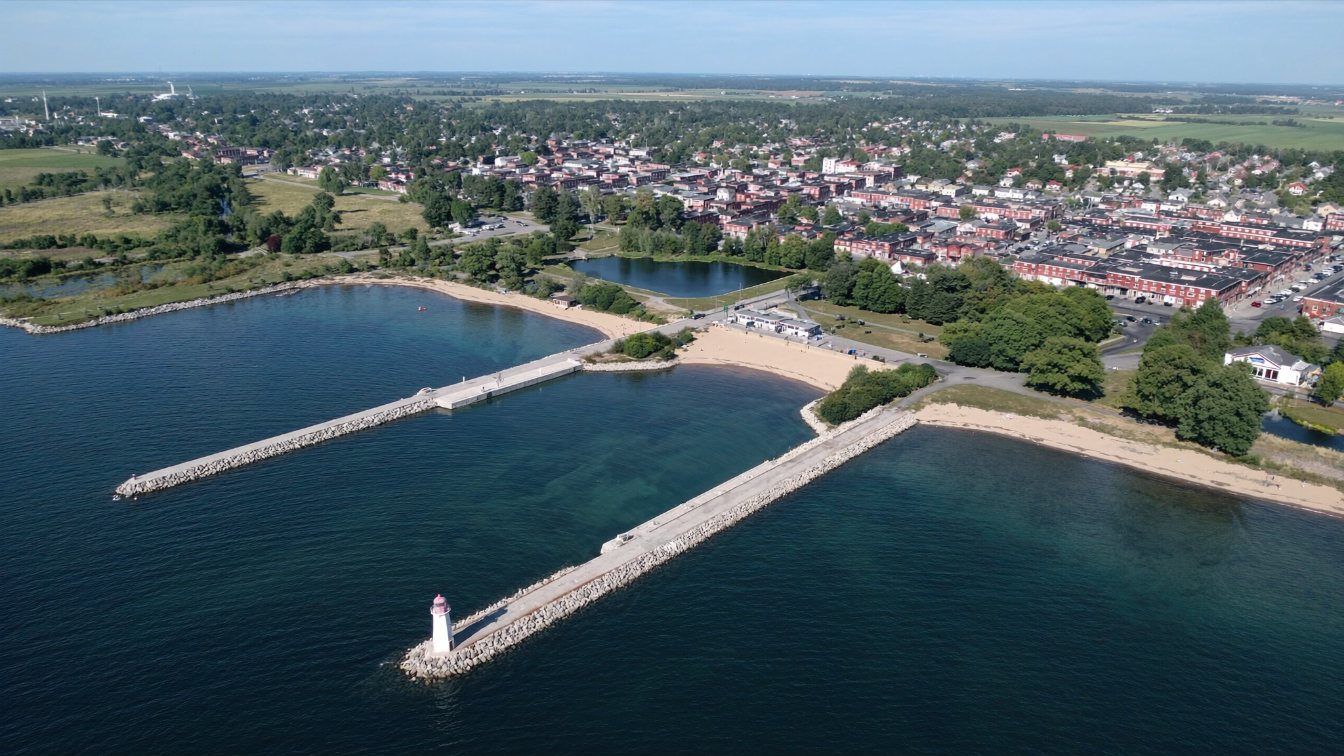
Port Dalhousie is a peninsula in St. Catharines bounded by Lake Ontario, Martindale Pond and Twelve Mile Creek, and the harbour where the first three Welland Canals entered the lake from 1826 until 1932. It has been a heritage conservation district since By-law 2003-63 in March 2003, so exterior work and new construction in the district need a heritage permit. Its two piers, closed in 2015, were rebuilt by the federal government and reopened in June 2021, and in July 2022 Ottawa handed the piers, harbour lands and Lakeside Park to the City. The Niagara Peninsula Conservation Authority regulates both the lake shore and the pond and creek. St. Catharines allows short-term rentals only in the operator’s principal residence, with a $534.05 licence fee. The Niagara Association of REALTORS’ regional benchmark was $569,800 in August 2026, and TRREB’s spring community report put Port Dalhousie’s average at $912,019, the city’s Lakeshore community at $881,962 and Martindale Pond at $917,710.
The geography: a peninsula with three waters
Port Dalhousie sits on a peninsula with Lake Ontario to the north, Martindale Pond and Twelve Mile Creek to the south and the harbour to the east. That means three kinds of waterfront within a few streets: open lake at Lakeside Beach, the sheltered pond that has hosted the Royal Canadian Henley Regatta since 1903, and the harbour with its piers and lighthouses. East along the city’s shore, Sunset Beach lies beside the mouth of the present Welland Canal at Port Weller, and Niagara Region Public Health samples both beaches from Victoria Day to Labour Day. St. Catharines’ lakefront houses are concentrated in Port Dalhousie itself and in the Lakeshore area between the two beaches, with the Martindale Pond streets forming a third, water-facing pocket. There is no official inventory of lots with private frontage, and I will not name streets.
A heritage district since 2003
The Port Dalhousie Heritage Conservation District was designated by City By-law 2003-63 on 3 March 2003 under Part V of the Ontario Heritage Act. Its heritage value rests on the canal: Port Dalhousie was the Lake Ontario terminus of the First Welland Canal from 1826 and served the Second and Third canals until 1932, when the fourth canal moved the entrance to Port Weller. The district’s character-defining elements include the entry locks of the first three canals, the mid-to-late nineteenth-century commercial streetscape along Lakeport Road, Lock Street and Hogan’s Alley, the 1845 jail and customs house, the lighthouses, a lockkeeper’s shanty, shipyard remnants, an 1830s cemetery, Lakeside Park from 1902 and residential architecture from the 1820s onward.
For an owner the City puts it simply: you may need to buy a heritage permit before construction or renovation. A house in the district cannot be treated as a teardown by default, and exterior changes visible from the street are reviewed. Read how heritage designation works before you plan; the trade is a protected streetscape for a longer approvals path.
The piers, the park and the carousel
Port Dalhousie’s two piers closed in 2015 with significant structural defects. Fisheries and Oceans Canada rebuilt them from 2019, encasing them in new steel sheet piling with rock berms, and reopened them in June 2021; the work was described as a $28 million federal project. On 20 July 2022 the federal government transferred the piers, the harbour lands and Lakeside Park, which the City had leased since 1992, to the City of St. Catharines outright. Lakeside Park itself dates from 1902 and its carousel, carved by Charles Looff between 1898 and 1905 and brought to Port Dalhousie in 1921 from Toronto’s Scarborough Beach Park, still runs its 68 hand-carved animals for a fare stipulated to remain five cents forever, operated by the City with a volunteer friends group. The point for a buyer is that the public waterfront here is now municipally owned, recently rebuilt and permanent; nobody is going to sell the piers.
The redevelopment that has taken twenty years
Port Dalhousie’s harbour block has been the subject of redevelopment proposals since the 2000s. The City’s most recent public materials, from 2020, describe two approved projects: an eight-storey building at 57 Lakeport Road with a Royal Canadian Legion at grade and 49 condominium units, then under construction, and a nine-storey adaptive reuse of the former Lincoln Fabrics building at 61–63 Lakeport Road with a restaurant, six live-work units and 117 condominium units, approved through site plan, with conditions including a reconfigured Lockhart Point park and a widened Harbour Walk. Zoning amendments for both were approved in 2018. I could not verify their status in 2026 from sources I trust, so if you are buying near the harbour block, ask the City’s planning department what is built, what is occupied and what remains. Read buying near a planned development; the questions are the same in a heritage village.
NPCA rules on the lake, the pond and the creek
The Niagara Peninsula Conservation Authority administers Ontario Regulation 41/24 across St. Catharines. On the open shore its April 2024 Policy Document applies the Lake Ontario 100-year flood levels with wave uprush and an erosion hazard set by technical study, restricts new habitable buildings and ground-floor additions within the shoreline hazard, and permits reconstruction and repair of existing buildings under conditions. Around Martindale Pond and Twelve Mile Creek the regulation’s valley and floodplain rules apply instead, and the regulated area follows the watercourse, its floodplain and meander belt. A Port Dalhousie lot can be inside two hazard regimes at once. Pre-consult the NPCA and read the due diligence checklist; the order is the same, with a heritage permit added to the list.
Short-term rentals: principal residence only
St. Catharines has the strictest rental rule on this shore. Its short-term rental accommodation by-law, enforced through an administrative penalty system, requires that the property be the primary residence of the operator, owner or tenant, and operate first and foremost as a full-time residence; rentals may not exceed 28 consecutive days; one parking space per bedroom is required; the application fee is $534.05 for a two-year licence; and a two percent municipal accommodation tax has applied since 1 January 2023. A December 2024 amendment allowed tandem parking for bed-and-breakfast operators. A Port Dalhousie house bought as an investment rental is not a permitted use unless you live in it. The Niagara Association of REALTORS’ sales-to-listings ratio for St. Catharines was 46 percent in August 2026, a balanced market.
Getting there, services and taxes
St. Catharines GO and VIA station is downtown, not in Port Dalhousie, and is served by the existing Niagara GO trains that also stop at Confederation GO in Hamilton, open since 27 October 2025; Grimsby GO is under construction for 2027. The QEW crosses the city north of downtown. Urban St. Catharines is on Niagara Region water and sewer from the DeCew Falls plant. The 2026 urban residential tax rate is 1.842187 percent, combining city, region and education, with the city noting most properties fall under the urban rate that includes streetlights and transit; the City’s own example is a $258,000 assessment paying $4,752.85, up $173.65 from 2025. Assessments remain on January 2016 values.
What the August 2026 figures show
The Niagara Association of REALTORS reported 498 sales in August 2026 against 545 a year earlier, 1,152 new listings, 45 average days on market and a regional MLS Home Price Index composite benchmark of $569,800, down 6.2 percent year over year, with single-family homes at $593,000, townhouses at $530,600 and apartments at $342,400 on CREA’s page for the board. The association’s chair attributed part of the slowdown to two major storms that flooded parts of Niagara that summer. TRREB’s community report for April to June 2026 gives the local grain: Port Dalhousie 21 sales at an average of $912,019 and a median of $860,000, detached houses averaging about $882,000; the Lakeshore community 26 sales at $881,962 and a $762,500 median; Martindale Pond 10 sales at $917,710; Lakeport 33 sales at $577,364; Port Weller 8 at $619,113.
Those are community-wide figures on small samples, and a lakefront or pond-front lot in Port Dalhousie trades above them on its own comparables. Read how to price a lakefront house for the method.
The takeaway
Port Dalhousie is a canal village turned heritage district with three kinds of water, rebuilt piers the City now owns, a redevelopment block two decades in the making, NPCA hazards on lake and creek, and a principal-residence-only rental rule. St. Catharines’ other lake shore runs east to Port Weller. Add the heritage permit to the shoreline checklist and price the frontage apart from the community averages.
Where I fit
I work across Toronto and the GTA and follow clients down the QEW when a heritage village on the lake is the brief. Book a call to compare Port Dalhousie with Niagara-on-the-Lake and the Hamilton shore, or run the estimator below on the home you own now.
Free tool — AI home value estimator
Instant Home Valuation
What’s your home
worth today?
Answer six quick questions and get an instant value range built from current Toronto & GTA sale data — property type, size, condition, lot and location all weighted the way a real pricing conversation weighs them. Takes about ninety seconds.
Reading recent GTA sale data…
Building your estimate
Estimated market value
—
$0–$0
Most likely value $0 · roughly $0 per square foot
What moved the number
Starting from the area baseline for your property type, here’s what each answer added or subtracted.
Market context
Recent local averages for comparison.
—
A range is a starting point.
A strategy is what sells.
This model doesn’t know that your neighbour’s identical semi went $80,000 over asking last month, or which two upgrades actually pay back in your area. That conversation is free and takes twenty minutes.
Frequently asked questions
Is Port Dalhousie a heritage district?
Yes. The Port Dalhousie Heritage Conservation District was designated by City By-law 2003-63 on 3 March 2003 under Part V of the Ontario Heritage Act. Owners may need a heritage permit before construction or renovation.
Are the Port Dalhousie piers open?
Yes. They closed in 2015, were rebuilt by Fisheries and Oceans Canada and reopened in June 2021, and were transferred to the City of St. Catharines along with the harbour lands and Lakeside Park on 20 July 2022.
Can I run an Airbnb in Port Dalhousie?
Only in your principal residence. St. Catharines requires the property to be the operator’s primary residence, limits stays to 28 consecutive days, and charges a $534.05 fee for a two-year licence plus a two percent accommodation tax.
Who regulates the Port Dalhousie shoreline?
The Niagara Peninsula Conservation Authority under Ontario Regulation 41/24, covering the Lake Ontario shore, Martindale Pond and Twelve Mile Creek. New habitable buildings are restricted within the shoreline hazard.
Where is the GO station for Port Dalhousie?
St. Catharines GO and VIA station is downtown, a drive from Port Dalhousie, and is served by the Niagara GO trains that also stop at Confederation GO in Hamilton.
What is the property tax rate in St. Catharines?
The 2026 urban residential rate is 1.842187 percent, combining city, region and education. The City’s example is a $258,000 assessment paying $4,752.85.
What are house prices in Port Dalhousie?
TRREB’s April to June 2026 community report shows 21 sales at an average of $912,019 and a median of $860,000. The Niagara Association of REALTORS’ regional benchmark was $569,800 in August 2026. Neither is waterfront-specific.
Sources
- Canada’s Historic Places — Port Dalhousie Heritage Conservation District — By-law 2003-63, character elements
- City of St. Catharines — Port Dalhousie Heritage District — heritage permits
- Fisheries and Oceans Canada, 2 June 2021 — Port Dalhousie piers rehabilitation complete — pier reopening
- insauga, 20 July 2022 — St. Catharines owns Port Dalhousie waterfront land and piers — transfer to City
- City of St. Catharines — Port Dalhousie harbour area developments — 57 and 61–63 Lakeport Road
- City of St. Catharines — Short-term rental licensing — principal residence, fees
- NPCA — Policy Document, 15 April 2024 — shoreline hazard policies
- Niagara Region — Beach water quality — Lakeside and Sunset beaches
- City of St. Catharines — Tax payments and rates — 2026 urban rate
- Wikipedia — Lakeside Park Carousel — carousel history
- Niagara Association of REALTORS® — August 2026 statistics (reproduced) — regional figures
- TRREB — Community Housing Market Report, St. Catharines, Q2 2026 — Port Dalhousie, Lakeshore, Martindale Pond
Related reading
- Waterfront homes in the GTA: the complete guide
- Niagara-on-the-Lake waterfront homes
- Lincoln lakefront homes
- Heritage designation under the Ontario Heritage Act
- Old Oakville lakefront homes
- What $1.2 million buys on the GTA waterfront
About the author — Jatin Dua, Toronto and GTA real estate broker
I am Jatin Dua, Broker of Record and co-founder of RE/MAX Quantum Realty Inc., Brokerage, Unit 101, 799 The Queensway, Etobicoke. I work with buyers and sellers across Toronto and the GTA, with deep local knowledge of the west end and the Lake Ontario shoreline. Four-plus years of active GTA transactions and over $100 million in sales volume. Every market figure here comes from TRREB’s published tables and every rule from the regulator or the legislation, so you can check all of it without asking me.
Reach me at connect@jatindua.com or 833-330-1925, or book a call.