

Published 26 September 2026 · By Jatin Dua, Broker of Record, RE/MAX Quantum Realty
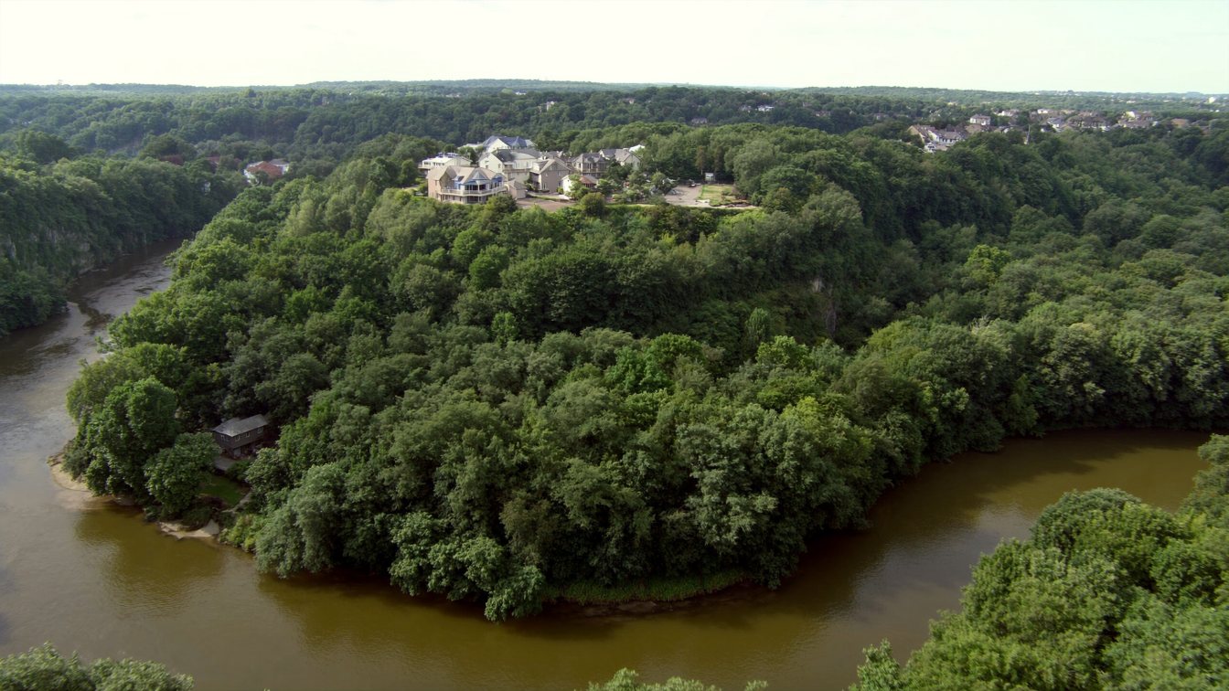
The GTA has far more riverfront than lakefront. The Humber, Credit, Don and Rouge and creeks like Etobicoke, Mimico and Sixteen Mile run through the region in valleys lined with some of its most expensive houses, from Baby Point and the Kingsway to Erindale, Mineola and Rosedale. A ravine lot is waterfront with different physics: the hazard is slope failure and flash flooding measured in hours, not lake levels measured in seasons. Every valley is regulated under Ontario Regulation 41/24 by TRCA, Credit Valley Conservation or Conservation Halton, with the regulated area reaching 15 metres beyond the stable top of bank and no development within 30 metres of a wetland. In Toronto, Chapter 658 adds a ravine by-law under which no tree may be injured or removed, no fill placed and no grade changed in a protected area without a permit, with changes effective 1 September 2026. Hurricane Hazel in 1954 killed 81 people and set the floodplain rule still in force. The buildable envelope is the table land; the slope is view, privacy and liability.
Waterfront with different physics
Lake Ontario floods slowly: a high-water year builds over months and the record months of 2017 and 2019 were forecast weeks ahead. A river floods in hours. On 8 July 2013 more than 120 millimetres fell at Pearson in a day, a GO train was stranded in the Don with about 1,400 passengers aboard, 300,000 lost power and damage reached about $1.5 billion. On 16 July 2024 Pearson recorded 97.8 millimetres in a morning after two wet days, Union Station and the Don Valley Parkway flooded, and insured losses were later put at roughly a billion dollars. Neither event moved the lake. Both moved the rivers, and every ravine lot in this guide sits above one.
The second difference is the ground itself. A lakefront lot erodes at the edge; a ravine lot can fail along its slope. That is why the regulators speak of a stable top of bank rather than a shoreline, why a geotechnical report is normal for a pool or an addition near the edge, and why the standard home insurance exclusion for earth movement matters more here than anywhere on the lake. The Insurance Bureau’s own consumer material says plainly that earth movement is not covered and that no coverage is currently available. Read your policy’s exclusion before you fall for the view.
Which authority regulates which valley
Ontario Regulation 41/24 took effect on 1 April 2024 and defines the regulated area for every conservation authority. For a river or stream valley with stable slopes it runs from the stable top of bank plus 15 metres on each side; where the slope is unstable, from the predicted long-term stable slope, or the toe after 100 years of erosion, plus 15 metres; where valley walls are not apparent, from the further of the regulatory floodplain or the predicted meander belt plus 15 metres. Development within 30 metres of a wetland is prohibited without a permit.
- TRCA regulates the Humber, including Baby Point, the Kingsway, Humber Valley Village and Lambton, the Don and its Rosedale and Hoggs Hollow ravines, the Rouge, Etobicoke Creek and Mimico Creek, and Toronto’s lake shore. It needs permits for decks, pools, additions, new and replacement houses, decides completeness in 14 or 21 days and permits in 21 or 28 days after that, updated its fees on 1 February 2026 and runs a property inquiry service and an online regulated-area search.
- Credit Valley Conservation regulates the Credit through Erindale, Streetsville, the golf-club lands and the Mineola ravine; its board approved updated regulation mapping on 20 February 2026 with an online viewer.
- Conservation Halton regulates Sixteen Mile Creek in Oakville and lists gazebos, decks, sheds, stairs and retaining walls among the works needing permission, with completeness in 21 days and a legislated 90-day maximum.
TRCA’s definitions are the ones to learn: the stable top of bank is set by geotechnical study, with a rule of thumb of three times the slope height for defined valleylands; the toe erosion allowance guards against the river undercutting the bank; and the erosion access allowance leaves room for people and machines to reach the slope in an emergency. Read conservation authority regulated land for the permit process itself.
Toronto’s ravine by-law
Inside the City of Toronto, Municipal Code Chapter 658, the Ravine and Natural Feature Protection By-law, adds a second layer. In a protected area, which the by-law’s maps define to include ravines with at least two metres of elevation change and evidence of water flow, tableland forests, the treed Lake Iroquois shoreline, Rouge Park and valley parks and golf courses, no person may injure, destroy or remove any tree, place or dump fill, or alter the grade of the land without a permit. Fines run from $500 per tree to $100,000, with continuing offences at up to $10,000 a day. Effective 1 September 2026 the City implemented changes to its tree and ravine by-laws with stronger protection for existing trees, new application fees and enhanced enforcement, and issued a new permit application form the same day; read the City’s tree by-law review pages for the current thresholds before you quote a landscaper. The 2017 Ravine Strategy, whose implementation Council adopted in January 2020 with new annual funding, frames the whole system, more than 300 kilometres of ravine and a 65-kilometre Loop Trail, as public infrastructure. A ravine lot is private land inside a public system, and the by-law is how the City reminds you.
Hazel, the floodplain and the Special Policy Areas
On 15 October 1954 Hurricane Hazel dropped 285 millimetres over 48 hours on the Toronto region and killed 81 people, many of them on the Humber. The response built the system a ravine buyer lives under: the conservation authority itself in 1957, a program that moved floodplain land into public hands, dams, channels and floodplain mapping, and the rule that new development is kept out of the floodplain. TRCA’s regulatory flood is the more severe of Hazel and the 100-year storm. The exceptions are Special Policy Areas, historic communities already in the floodplain where provincial policies allow existing uses to continue; Rockcliffe-Smythe on Black Creek is the verified example, channelised in the 1960s and flooded again in 2013, 2019 and 2020, with a no-fault grant program for basement damage. Other neighbourhoods are often described as SPAs; check the Official Plan before repeating it. If a listing sits in a floodplain, the question is not whether it can flood but what the policy allows you to rebuild after it does.
Basement flooding: the subsidies grew in 2026
The most common river-valley loss is not a house in the water; it is water in the basement. Toronto’s Basement Flooding Protection Subsidy Program expanded effective 1 May 2026 for work done on or after 12 November 2025: up to $6,650 per property, covering a $500 plumbing assessment, $1,600 per backwater valve for up to two, $2,250 for a sump pump plus $300 for battery backup, and $400 for severing weeping-tile connections, each at up to 80 percent of cost, for owners of single-family homes to fourplexes applying within two years of installation. Mississauga’s Basement Flooding Prevention Rebate, with pre-approval required since February 2025, pays up to $7,500: $6,000 for a sump pump, $1,500 for a storm backwater valve, $1,000 for capping foundation drains and $125 per downspout disconnection. Sewer backup and overland water are both optional insurance endorsements, not standard coverage. On a ravine lot, install the valve and the pump, take the subsidy, and buy the endorsements before the first storm.
How a ravine lot is actually valued
MPAC lists ravines and topography among the site influences in its assessment method and treats waterfront as a market area, but it publishes no ravine adjustment factor, so what follows is appraisal practice, not policy. A ravine lot is two lots. The buildable table land, from the street to the stable top of bank plus the allowances and the 15-metre regulated line, is priced like any lot in the neighbourhood, and it is often smaller than the deed suggests. The slope and valley portion is priced at a discount because it cannot be built on, and then a premium is added for what the slope gives: privacy, a view, a boundary that will never have a neighbour on it. Subtract for what it takes: geotechnical and permit costs for anything near the edge, the tree by-law, the earth-movement exclusion, and any evidence of slope movement.
The market’s verdict is visible in TRREB’s April to June 2026 community tables, where the valley neighbourhoods sit at the top of their districts: Lambton Baby Point averaged $1,912,711 across 19 sales with detached houses at about $2,096,000; Kingsway South $2,312,443 across 33; Rosedale-Moore Park $2,441,401 across 73; Bridle Path-Sunnybrook-York Mills, which contains Hoggs Hollow, $3,492,858 across 40; and in Mississauga the Credit River’s Mineola $2,200,967 across 33. Those are whole-community averages, not ravine-lot figures, against a City of Toronto detached average of $1,525,749 in August 2026. The ravine premium is real, and so is the smaller envelope behind it.
The takeaway
Ravine and river lots are the GTA’s other waterfront: flash floods in hours instead of lake levels in seasons, slope failure instead of shoreline erosion, and an earth-movement exclusion in every policy. TRCA, CVC or Conservation Halton regulate to 15 metres past the stable top of bank, Toronto’s Chapter 658 protects every tree and every grade change, Hazel’s floodplain rule still governs, and the subsidies for a backwater valve and sump pump now reach $6,650 in Toronto and $7,500 in Mississauga. Value the table land as the lot, the slope as the view, and get the geotechnical report before the architect.
Where I fit
Ravine lots are where much of my Toronto and Mississauga work happens, and the first thing I do with one is pull the conservation authority mapping and the top-of-bank survey. If you are buying or selling on a valley, book a call, or run the estimator below on the home you own now.
Free tool — AI home value estimator
Instant Home Valuation
What’s your home
worth today?
Answer six quick questions and get an instant value range built from current Toronto & GTA sale data — property type, size, condition, lot and location all weighted the way a real pricing conversation weighs them. Takes about ninety seconds.
Reading recent GTA sale data…
Building your estimate
Estimated market value
—
$0–$0
Most likely value $0 · roughly $0 per square foot
What moved the number
Starting from the area baseline for your property type, here’s what each answer added or subtracted.
Market context
Recent local averages for comparison.
—
A range is a starting point.
A strategy is what sells.
This model doesn’t know that your neighbour’s identical semi went $80,000 over asking last month, or which two upgrades actually pay back in your area. That conversation is free and takes twenty minutes.
Frequently asked questions
Who regulates a ravine lot in Toronto?
The Toronto and Region Conservation Authority under Ontario Regulation 41/24, to 15 metres beyond the stable top of bank, plus the City’s Ravine and Natural Feature Protection By-law, Chapter 658, which requires a permit to remove trees, place fill or change grades in protected areas. Credit Valley Conservation covers the Credit and Conservation Halton covers Sixteen Mile Creek.
Can I build a pool or addition on a ravine lot?
Only outside the hazard and with permits. TRCA lists decks, pools, additions and replacement houses among works needing a permit, and a geotechnical study typically sets the stable top of bank. In Toronto, any tree removal or grade change in the protected area also needs a Chapter 658 permit.
Does home insurance cover a ravine slope failure?
No. Earth movement is excluded from standard Canadian home policies and, according to the Insurance Bureau’s consumer material, no coverage is available. Overland water and sewer backup are optional endorsements.
What is a Special Policy Area?
A community that historically existed in a floodplain where provincial policies allow existing uses to continue under site-specific rules, since new development is otherwise kept out of the floodplain. Rockcliffe-Smythe on Black Creek is a verified Toronto example.
How much is Toronto’s basement flooding subsidy?
Up to $6,650 per property since 1 May 2026 for work done on or after 12 November 2025, including $1,600 per backwater valve, $2,250 for a sump pump and $300 for battery backup. Mississauga’s rebate is up to $7,500.
How is a ravine lot valued?
In practice, as two lots: the buildable table land priced at the neighbourhood rate and the slope discounted because it cannot be built on, then adjusted for privacy and view, geotechnical and permit constraints and insurance exclusions. MPAC publishes no ravine adjustment factor.
What caused Toronto’s worst floods?
Hurricane Hazel on 15 October 1954, with 285 millimetres over 48 hours and 81 deaths; more than 120 millimetres at Pearson on 8 July 2013; and 97.8 millimetres in a morning on 16 July 2024. All were river and urban floods, not lake floods.
Sources
- Ontario Regulation 41/24 — text as reproduced by Cataraqui Region Conservation Authority — regulated area definitions
- TRCA — Planning and permits FAQs — permit scope and timelines
- TRCA — Glossary — stable top of bank, allowances
- Credit Valley Conservation — Regulation mapping — Feb 2026 mapping update
- Conservation Halton — Permitting — works requiring permission
- City of Toronto — Municipal Code Chapter 658, Ravine and Natural Feature Protection — prohibitions and fines
- City of Toronto — Tree and ravine protection permits — changes effective 1 Sept 2026
- City of Toronto — Ravine Strategy — principles, Loop Trail
- TRCA — Hurricane Hazel, 70 years — 1954 rainfall and deaths
- TRCA — Flood risk area: Rockcliffe-Smythe — Special Policy Area
- CP24, 3 Sept 2026 — Some of the worst floods to hit the Toronto area — 2013 and 2024 floods
- City of Toronto — Basement Flooding Protection Subsidy Program — $6,650 from May 2026
- City of Mississauga — Basement flooding prevention rebate — $7,500 maximum
- Insurance Bureau of Canada — Flood and water — optional endorsements
- MPAC — How we assess residential properties — site influences
- TRREB — Community Housing Market Reports, Toronto West and Central, Q2 2026 — valley neighbourhood averages
Related reading
- Waterfront homes in the GTA: the complete guide
- Conservation authority regulated land: TRCA and CVC
- Shoreline erosion and your property line
- Flood insurance on a waterfront home
- Mineola, Port Credit and Lakeview houses
- What $2 million buys on the GTA waterfront
About the author — Jatin Dua, Toronto and GTA real estate broker
I am Jatin Dua, Broker of Record and co-founder of RE/MAX Quantum Realty Inc., Brokerage, Unit 101, 799 The Queensway, Etobicoke. I work with buyers and sellers across Toronto and the GTA, with deep local knowledge of the west end and the Lake Ontario shoreline. Four-plus years of active GTA transactions and over $100 million in sales volume. Every market figure here comes from TRREB’s published tables and every rule from the regulator or the legislation, so you can check all of it without asking me.
Reach me at connect@jatindua.com or 833-330-1925, or book a call.